Gov. Ron DeSantis warned time is “running out quickly” for people to prepare for large, life-threatening Hurricane Helene, which was already a Category 2 storm Thursday morning as it raced toward making landfall on North Florida’s Gulf Coast.
“It is possible that this storm could make landfall as a major hurricane, as a Category 3, or even potentially a Category 4,” DeSantis said during a morning news conference at the state Emergency Operations Center. “It is moving fast. More rainfall is, of course, expected. And it could lead to a significant storm surge in our coastal areas.”
Tracking models have placed potential landfall in the Big Bend region, south of Tallahassee. DeSantis pointed to indications the track could move somewhat east, similar to last year’s Hurricane Idalia, which made landfall in rural Taylor County.
“To the extent that it is tracking east and mirroring more of an Idalia track, rather than a direct hit on Tallahassee, that is going to impact the extent of the damage,” he said.
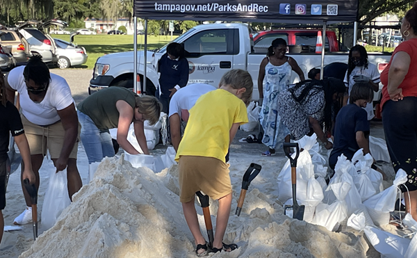
State Division of Emergency Management Director Kevin Guthrie said residents had time to evacuate before expected landfall Thursday night, “but that time is now. It’s right now.” A major concern was storm surge in low-lying coastal areas.
“There is a danger of potential life-threatening storm surge along the West Coast of Florida, including the Big Bend,” Guthrie added. “Some areas could experience 3 to 5 (feet) and as much as 15 feet of storm surge today.”
Beyond storm surge and damaging winds, Florida faces tornadoes, flooding hundreds of miles inland and widespread power outages. Utilities have positioned thousands of workers and brought in crews from other states to help restore electricity after the storm passes.
“Hurricane Helene poses a significant threat to Florida’s Big Bend and other communities along the state’s West Coast,” Todd Fountain, Duke Energy Florida storm director, said Thursday in a prepared statement. “The potential of a Category 4 storm can cause widespread damage to our equipment resulting in extended outage durations for our customers. We can’t overstate how critical it is for our customers in these areas to keep safety top of mind in the hours and days ahead.”
DeSantis cautioned against people going outside to inspect damage immediately after the storm passes, as it likely will still be dark.
“Do not try to do any work in the dark. You don't know what hazards are out there,” DeSantis said.
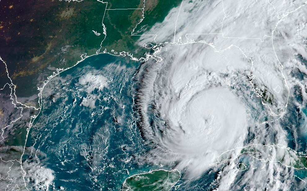
As of 8 a.m. Thursday, Helene was in the Gulf of Mexico about 515 miles southwest of Tampa with maximum sustained winds of about 100 mph. It was moving north-northwest at 12 mph.
The system is expected to continue to grow, reaching a Category 4 hurricane on the Saffir-Simpson Hurricane Wind Scale.
The meteorological company AccuWeather forecast maximum sustained winds of 130 mph to 156 mph Thursday afternoon. Gusts could blow at 140 mph to 160 mph.
"Confidence continues to grow among our experts for a landfall Thursday evening in the Big Bend area of the Florida Gulf Coast, which is the zone from the eastern part of the Florida Panhandle to the northwestern part of the Florida Peninsula,” AccuWeather Chief On-Air Meteorologist Bernie Rayno said in a statement. “At the time of landfall, Helene is expected to be a dangerous major hurricane.”
The National Hurricane Center said Helene on Thursday morning started to make an expected turn toward the north-northeast. The storm is expected to sustain strong winds inland until the center of the storm reaches northern Georgia, according to the hurricane center.
Hurricane warnings were in effect across the Big Bend region and nearly down to Tampa. Tropical storm warnings covered all of Florida outside of the western part of the Panhandle.
— News Service Assignment Manager Tom Urban contributed to this report.
Subscribe to Creative Loafing newsletters.
Follow us: Google News | NewsBreak | Reddit | Instagram | Facebook | Twitter
“It is possible that this storm could make landfall as a major hurricane, as a Category 3, or even potentially a Category 4,” DeSantis said during a morning news conference at the state Emergency Operations Center. “It is moving fast. More rainfall is, of course, expected. And it could lead to a significant storm surge in our coastal areas.”
Tracking models have placed potential landfall in the Big Bend region, south of Tallahassee. DeSantis pointed to indications the track could move somewhat east, similar to last year’s Hurricane Idalia, which made landfall in rural Taylor County.
“To the extent that it is tracking east and mirroring more of an Idalia track, rather than a direct hit on Tallahassee, that is going to impact the extent of the damage,” he said.
State Division of Emergency Management Director Kevin Guthrie said residents had time to evacuate before expected landfall Thursday night, “but that time is now. It’s right now.” A major concern was storm surge in low-lying coastal areas.
“There is a danger of potential life-threatening storm surge along the West Coast of Florida, including the Big Bend,” Guthrie added. “Some areas could experience 3 to 5 (feet) and as much as 15 feet of storm surge today.”
Beyond storm surge and damaging winds, Florida faces tornadoes, flooding hundreds of miles inland and widespread power outages. Utilities have positioned thousands of workers and brought in crews from other states to help restore electricity after the storm passes.
“Hurricane Helene poses a significant threat to Florida’s Big Bend and other communities along the state’s West Coast,” Todd Fountain, Duke Energy Florida storm director, said Thursday in a prepared statement. “The potential of a Category 4 storm can cause widespread damage to our equipment resulting in extended outage durations for our customers. We can’t overstate how critical it is for our customers in these areas to keep safety top of mind in the hours and days ahead.”
DeSantis cautioned against people going outside to inspect damage immediately after the storm passes, as it likely will still be dark.
“Do not try to do any work in the dark. You don't know what hazards are out there,” DeSantis said.
As of 8 a.m. Thursday, Helene was in the Gulf of Mexico about 515 miles southwest of Tampa with maximum sustained winds of about 100 mph. It was moving north-northwest at 12 mph.
The system is expected to continue to grow, reaching a Category 4 hurricane on the Saffir-Simpson Hurricane Wind Scale.
The meteorological company AccuWeather forecast maximum sustained winds of 130 mph to 156 mph Thursday afternoon. Gusts could blow at 140 mph to 160 mph.
"Confidence continues to grow among our experts for a landfall Thursday evening in the Big Bend area of the Florida Gulf Coast, which is the zone from the eastern part of the Florida Panhandle to the northwestern part of the Florida Peninsula,” AccuWeather Chief On-Air Meteorologist Bernie Rayno said in a statement. “At the time of landfall, Helene is expected to be a dangerous major hurricane.”
The National Hurricane Center said Helene on Thursday morning started to make an expected turn toward the north-northeast. The storm is expected to sustain strong winds inland until the center of the storm reaches northern Georgia, according to the hurricane center.
Hurricane warnings were in effect across the Big Bend region and nearly down to Tampa. Tropical storm warnings covered all of Florida outside of the western part of the Panhandle.
— News Service Assignment Manager Tom Urban contributed to this report.
Subscribe to Creative Loafing newsletters.
Follow us: Google News | NewsBreak | Reddit | Instagram | Facebook | Twitter