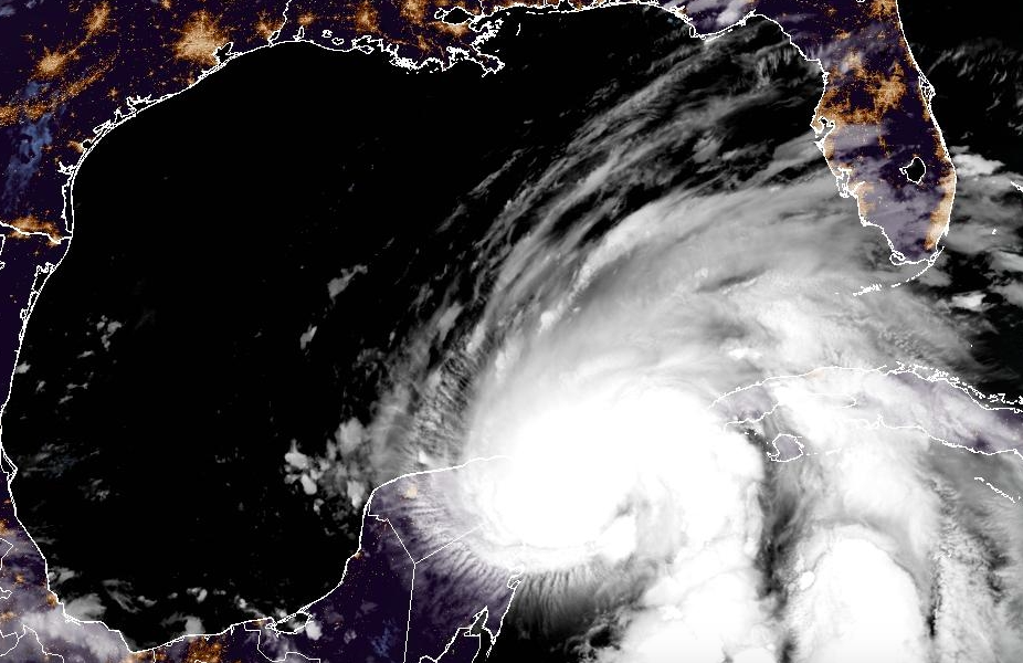
Tropical Storm Helene's path hasn't shifted much since yesterday, but the storm is expected to "rapidly intensify" and grow into a major hurricane, possible Category 3 or higher, before making landfall along Florida's Gulf Coast Thursday.
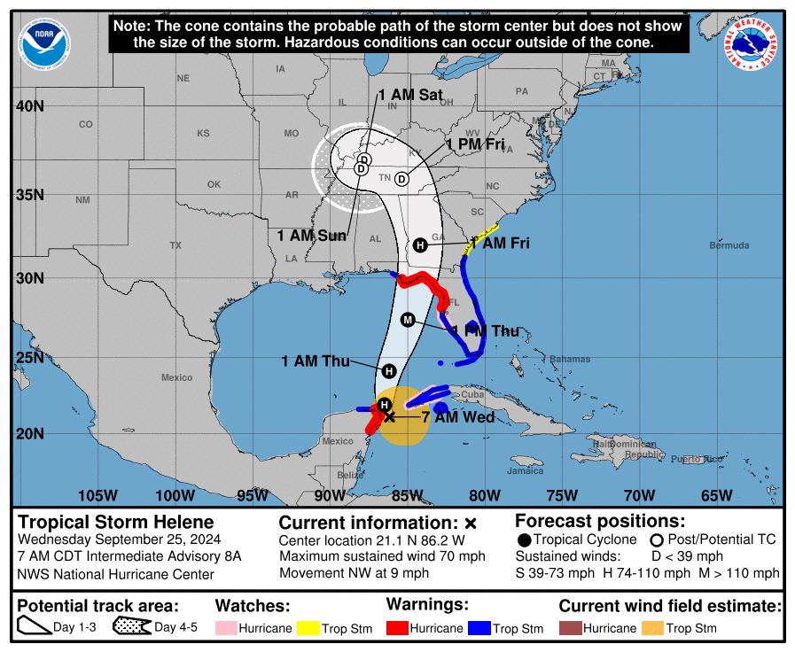
According to the National Hurricane Center's 5 a.m. advisory, the center of Helene is still moving northwest in the northern Caribbean Sea, about 60 miles east by northeast of Cozumel, Mexico and roughly 100 miles west by northwest of the western tip of Cuba.
The storm is currently moving 9 mph with sustained winds of 70 mph.
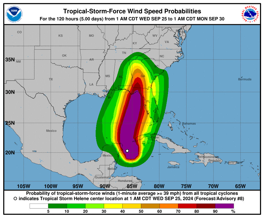
Like yesterday, Helene is still expected to make landfall in North Florida’s Big Bend region or in the Panhandle, with Tampa Bay staying slightly to the east. However, forecasters are stressing that hurricane conditions will be felt way east of the cone.
As of now, there's a hurricane warning in effect for a large stretch of Florida's Gulf Coast, from Anclote River to Mexico Beach. A tropical storm warning is in effect for Tampa Bay. There's also a storm surge warning and a flood watch for Pinellas, Hillsborough, Pasco and Hernando counties. "Helene is expected to rapidly intensify and grow in size over the eastern Gulf of Mexico," says the NHC. "There is a danger of life-threatening storm surge along the entire west coast of the Florida Peninsula and Florida Big Bend. The highest inundation levels are expected along the coast of the Florida Big Bend. Residents in those areas should follow advice given by local officials and evacuate if told to do so."
Officials are warning that Tampa Bay residents should make final preparations now, since Helene's bands are expected to arrive this evening.
Tampa Bay should see the worst conditions begin to materialize Thursday afternoon and into Friday morning, bringing gusts from 60 to 80 mph along the coast, and inland areas seeing gusts of 40 to 60 mph. Tampa Bay is also expected to see strong storm surge of 5 to 8 feet, as well as 5 to 10 inches of rainfall with some areas around 15 inches.
Localized flooding and tornadoes are also possible, warns the NHC.
Some residents in Pasco, Pinellas and Hernando counties should be prepared to evacuate today, as local orders have already been issued for multiple zones.
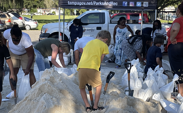
Local cities and counties are distributing free sandbags throughout today.
Subscribe to Creative Loafing newsletters.
Follow us: Google News | NewsBreak | Reddit | Instagram | Facebook | Twitter
According to the National Hurricane Center's 5 a.m. advisory, the center of Helene is still moving northwest in the northern Caribbean Sea, about 60 miles east by northeast of Cozumel, Mexico and roughly 100 miles west by northwest of the western tip of Cuba.
The storm is currently moving 9 mph with sustained winds of 70 mph.
Like yesterday, Helene is still expected to make landfall in North Florida’s Big Bend region or in the Panhandle, with Tampa Bay staying slightly to the east. However, forecasters are stressing that hurricane conditions will be felt way east of the cone.
As of now, there's a hurricane warning in effect for a large stretch of Florida's Gulf Coast, from Anclote River to Mexico Beach. A tropical storm warning is in effect for Tampa Bay. There's also a storm surge warning and a flood watch for Pinellas, Hillsborough, Pasco and Hernando counties. "Helene is expected to rapidly intensify and grow in size over the eastern Gulf of Mexico," says the NHC. "There is a danger of life-threatening storm surge along the entire west coast of the Florida Peninsula and Florida Big Bend. The highest inundation levels are expected along the coast of the Florida Big Bend. Residents in those areas should follow advice given by local officials and evacuate if told to do so."
Officials are warning that Tampa Bay residents should make final preparations now, since Helene's bands are expected to arrive this evening.
Tampa Bay should see the worst conditions begin to materialize Thursday afternoon and into Friday morning, bringing gusts from 60 to 80 mph along the coast, and inland areas seeing gusts of 40 to 60 mph. Tampa Bay is also expected to see strong storm surge of 5 to 8 feet, as well as 5 to 10 inches of rainfall with some areas around 15 inches.
Localized flooding and tornadoes are also possible, warns the NHC.
Some residents in Pasco, Pinellas and Hernando counties should be prepared to evacuate today, as local orders have already been issued for multiple zones.
Local cities and counties are distributing free sandbags throughout today.
Subscribe to Creative Loafing newsletters.
Follow us: Google News | NewsBreak | Reddit | Instagram | Facebook | Twitter