Tampa businessman Tom Touchton began collecting maps 31 years ago during a trip to London with his wife. As the couple toured an antiques fair, he homed in on an unfamiliar sight — a young man whose booth displayed not art or furniture, but maps pinned to the walls. “Who buys maps?” Touchton recalls asking incredulously. The young man gave him some magazines about map collecting, which Touchton devoured overnight in his hotel room. By morning, he had convinced his wife to visit a map dealer whose shop happened to be located across the street from their hotel.
“I walked into the map shop … and said ‘I’m going to collect maps. Can you help me?’” Touchton says.
Several thousand maps later, Touchton owns what may be the definitive collection of Florida cartography in the world. Between now and February, 125 of his maps are on display at the Tampa Bay History Center exhibition Charting the Land of the Flowers: 500 Years of Florida Maps, timed to coincide with the 500th anniversary of Ponce de León’s exploration and naming of the state. Touchton describes it as “the most comprehensive exhibition of Florida maps that has ever been done and is likely to be done.”
The exhibition offers a taste of what Touchton, who served as TBHC’s founding chairman and has been a key patron for the institution, ultimately intends: the donation of his map collection and creation of a Florida-themed cartographic center at the museum.
Charting showcases the results of a three-year collaboration. In consultation with Touchton, TBHC curator Rodney Kite-Powell winnowed down more than five centuries of Florida’s past into a selection of maps that the average museumgoer might hope to absorb during a visit. Loans of an additional 25 maps from collections around the world, including the U.S. Library of Congress and the Archivio di Stato in Florence, Italy, complement Touchton’s.
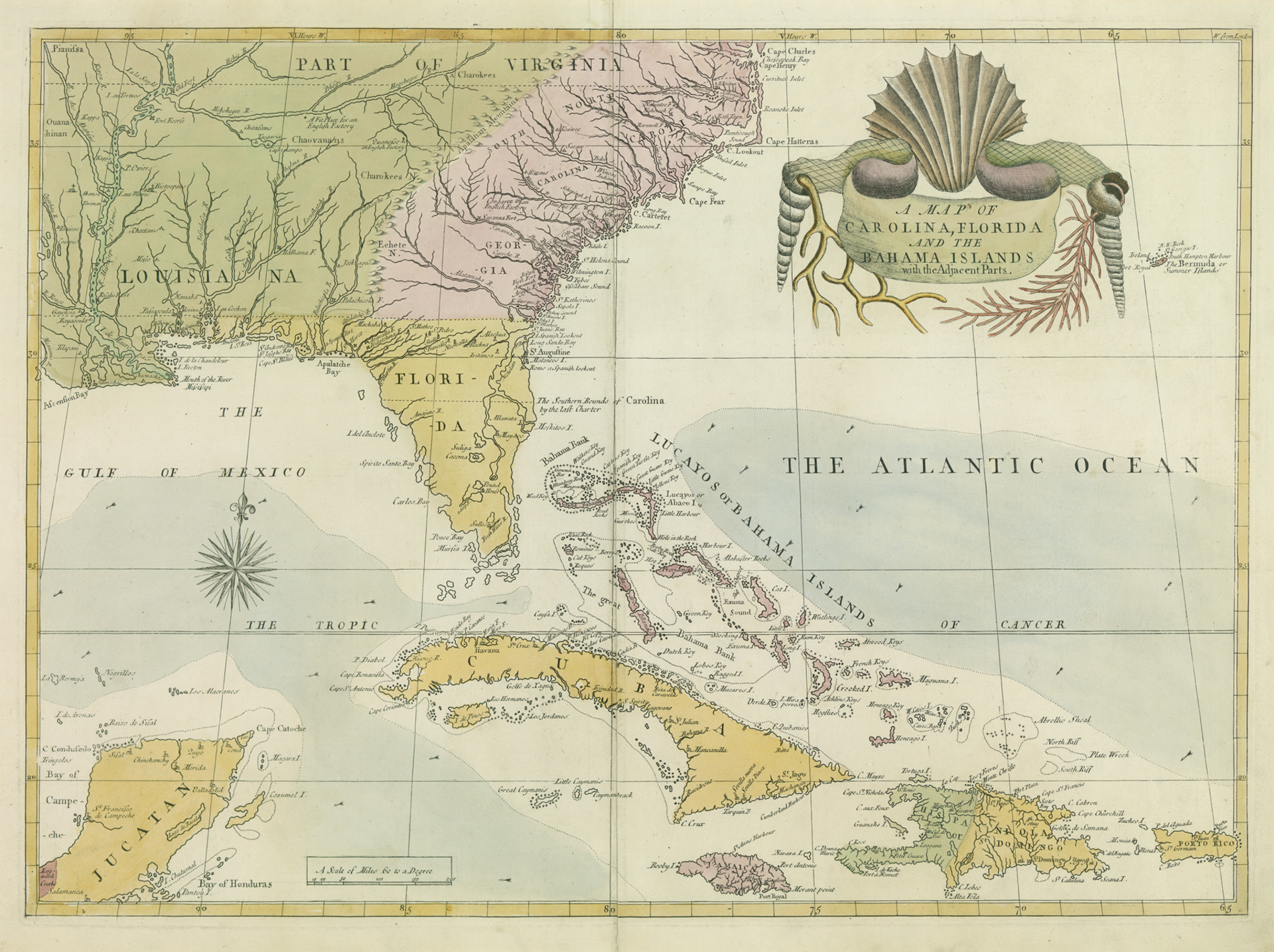
Collectively, the maps narrate the emergence of Florida from a nascent concept of the New World into the wild and woolly state of today. A woodcut map printed in Nuremburg in 1493 shows what was known of the world just before Columbus’s voyage: a dubious outline of Europe, Africa and the Near East with no sign of the Americas or anything east of what’s now called Bangladesh, bordered by medieval personifications of gusty winds and fantastical beasts. By 1514 or so, just after Ponce de León’s landing, Florida, Cuba and Latin America’s coastline make an appearance on a hand-drawn Italian portolan chart, sent from Florence as a high-resolution file and reproduced locally. By 1576, Spanish mapmaker Juan López de Velasco drafts an impressively accurate layout of the Caribbean that includes the first known identification of Tampa on a map.
What’s most interesting about the first half of the exhibition’s chronology is how mapmakers made sense of Florida. One cartographer working in 1524 gives it a passing mention on a map devoted to Aztec capital Tenochtitlan — the simultaneous decimation of which by Cortés is one of many fascinating, if appalling, historical events that the exhibit alludes to in passing. Over the next 200 years, mapmakers struggle with the territory’s shape, gradually transforming a pizza-like wedge that sometimes resembles India into the peninsula recognizable today.
Upon entering the 19th century, a viewer will have realized already that maps serve not only to document but also to enable endeavors such as colonization, enslavement and capitalization. If such ironies tickle your funnybone, you’ll get a kick out of objects like a beautiful lithographic map of Sanibel Island from 1833 used by the Florida Land Company to promote shady sales of “farm land” on the sand-covered isle to white pioneers. Their sales pitch, inscribed at the corner of the map, included a dig at displaced Indians for failing to cultivate the land.
The first known printed map of Tampa claims an equally fishy heritage. Produced in 1838 by Augustus Steele, the judge who brought Hillsborough County into existence, the simple grid was made to sell plots along the Hillsborough River downtown. Buyers included Odette Philippe, a Frenchman who would later plant grapefruit in Safety Harbor. The rub? Steele didn’t own the land, which he procured from his friend Richard Hackley, a prosperous squatter who claimed to own all of West Central Florida by virtue of a land grant from Spanish nobility. When the federal government responded by invalidating Hackley’s claim as Florida approached statehood in 1845, Hackley sued and lost.
Other highlights include 18th-century maps by naturalists John and William Bartram and Benjamin Franklin’s chart of the Gulf Stream; 19th-century depictions of St. Petersburg and Fort Myers; and 20th-century visions of Florida real estate developments — some destined to boom, some to go bust. The exhibit concludes with NASA photographs of the state and a video about Google Earth.
Selecting and organizing such an all-encompassing showcase in collaboration with History Center staff was “one of those ‘if-it-doesn’t-kill-us …’ experiences,” Touchton says. He expects a scaled-back version of the exhibition — some 20 to 30 maps — to travel to museums outside of Florida. Charting offers a rare chance to come face to face with Florida’s history in map form; think of it as a very special moment in time.